 |
| Looking south-west up the Vallee Blanche at the Mer de Glace glacier |
It was one of those
experiences you are sure to remember because it is so unique. The concept might
seem a bit random - strolling through frigid galleries that have been gouged
into glacial ice - but beyond that it was quite the adventure in itself just getting
to the place, even before we made the memorable hike inside.
 |
| Chamonix is in south-east France |
It happened during our
recent holiday in France this past July. We were in Chamonix - a town in the
south-eastern region of France called the Upper Savoy (Haute-Savoie). Chamonix is one of the oldest ski-resorts in France;
the first Winter Olympics were held there in 1924. But what to do there in
summer? On our first day in town we did a two-hour hike on the high alpine
slopes above the town - the grand balcon
sud between La Flégère and Planpraz. As you hike west along the trail Mont
Blanc is constantly in view; it's the highest point on the massif that rises sharply out of the valley on the southern side of
town. The following day we decided to try something a bit less strenuous - a close-up
trip to Mer de Glace, a nearby glacier; but the hike down to the glacier itself, and the steep
climb back up, were not that easy - especially in the ensuing mid-afternoon heat.
 |
| Glacier des Bossons overhanging Chamonix on the south side of the valley |
When you first arrive in
Chamonix, and fix your position relative to the high mountain peaks on the southern side of the Arve river valley, your gaze up towards the Mont Blanc
summit is dominated by a huge glacier flowing north, in its slow, inexorable
slide down towards town. This is the glacier
des bossons. It is a large glacier, but you can see from the physical
evidence that it has been rapidly receding in recent decades. But this is not
the glacier we visited. To get to our destination you have to get behind the Mont Blanc Massif and into the huge
White Valley (Vallée Blanche). There
is an even larger glacier there - the mer
de glace ("the sea of ice").
 |
| Chamonix in centre of valley; the mer de glace and glacier des bossons are the glaciers reaching furthest into the river valley |
But to get to the glaciers you need trains. Different types of trains. Now, I don't know about you, but
for me one of the enjoyable parts of travelling is negotiating the various
types of transportation: planes, boats, rented cars, bicycles, funiculars,
cable cars, subways and trains. I particularly enjoy train travel. And the
train network in France is excellent - well-organized, efficient, relatively
cheap, and quick. SNCF, the company that operates the French national rail
service, also runs the inter-city, high-speed train service called the TGV (Train à Grande Vitesse). During a train journey we
took between Dijon and Strasbourg, I noticed we were going really fast. I
looked up at the electronic sign at the end of the carriage; it listed the name
of the next station and the scheduled time of arrival. It also showed the exact
speed of the train. In this case, we were moving at 270 km/h. Fast - but soon we
started to pick up even greater speed. I kept an eye on the sign. For a stretch
of about twenty minutes, we averaged 320 km/h (200 mph).
 |
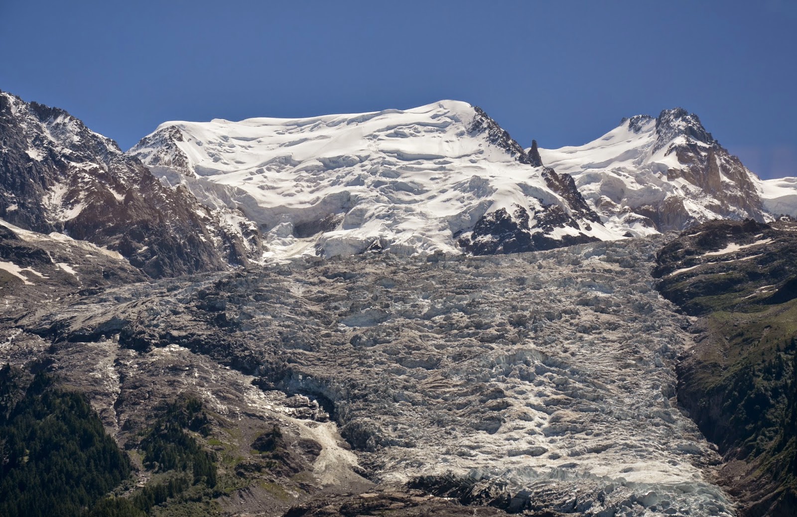
| The Mer de Glace is the largest and longest glacier in France |
Once you move into mountainous regions, the size
and speed of trains changes dramatically. Between Annecy and Chamonix, we had
to change trains at Gare de Saint-Gervais-les-Bains-Le Fayet. The rail line
taking us into the Chamonix valley - the Saint-Gervais-Vallorcine Railway
(dubbed the Mont Blanc Express) - switches from the standard gauge of the
national system (1435 mm) to a narrow gauge (1000 mm). The gauge measures the distance
between the tracks. The trains on this line travel more slowly; and they're smaller
- usually just two carriages. This is because they have to negotiate many
stretches of curved track; and they are climbing into the mountains - on one long
stretch of over 2 km, they have to negotiate a steep grade of 9%.
 |
| The Montenvers train to the Mer de Glace glacier uses a rack-and-pinion system - note the toothed rack rail in front of the train, which is grasped by a cog underneath the train |
But the train which takes you from Chamonix to
the mer de glace glacier is even smaller. The Montenvers Railway terminus
is right next to the SNCF station, in the centre of town. The Montenvers line (Chemin
de fer du Montenvers) was built in1909 for the tourist trade. It is 5 km
long, rising 871 metres (2,858 ft.) from Chamonix to the Hotel de Montenvers
station. This is also a narrow gauge track (1000 mm).
 |
| The train leaves Chamonix (near top-right); the line runs through the woods right to left, and then turns north at the edge of the Massif (left-middle); mer de glace is at the top-left of the image |
The gradient on the way
up varies from 11% to 22% - too steep for a conventional adhesion railway, in
which pressure is simply applied to the wheels, and friction is created between
wheels and tracks. For a gradient as steep as this one, a rack-and-pinion system
is required - consisting of a toothed rack rail, which usually sits between the
two running rails. The train will have one or more cog wheels (or pinions),
which then mesh with the rack rail. The Montenvers trains travel at a speed of
14-20 km/h (9-12 mph), taking 20 minutes to reach their destination.
 |
| The train arrives at the Hotel de Montenvers station |
When you reach the Hotel de Montenvers
station, you have skirted the north-east edge of the Mont Blanc Massif
and are perched on the western slope rising out of the Vallée Blanche. About
fifteen metres beyond the exit from the train station, there is a viewing
station. You stand behind a low stone wall and gaze at the incredible vista south-west
up the valley. Across the valley you can see the peaks of Les Drus and Les
Grands Jorasses. Further away, towards the south-west, is Aguille
du Grepon. But then you look down, way down. And there it is - the mer
de glace glacier.
 |
| Les Drus on the opposite side of the Vallee Blanche from Hotel de Montenvers |
Glaciers, when you think about it, are more like
rivers than seas; they flow downhill, pulled by the force of gravity. They are
created by the accumulation of snow over long expanses of time. As the depth of
snow reaches a critical mass, the pressure of the upper layer turns the lower
layer into ice. When there is a sufficient amount of ice layed out on a mountain
slope, the gravitational pull will begin to drag the ice very slowly downhill.
A glacier has been created. Glaciers form high up in mountains because it snows
a lot up there, and it is also cool enough at those high elevations to stall
significant melting during the summer season. Glaciers persist because there is
a sufficient accumulation of snow to overcome natural ablation - the ice's
tendency to melt and sublimate into water vapour.
 |
| Colin (in red) looks at Mer de Glace |
There are approximately 80 glaciers in the Alps.
Mer de glace is the largest and longest of the seven glaciers in France.
It originates on the northern slopes of the Mont Blanc Massif. Mer de
glace is 7 km long (4.3 miles) and 200 metres deep (660 ft.). It begins at
a height of 2,400 metres (7,900 ft.) and flows north by north-west down to
1,400 metres (4,600 ft.). How fast does it flow downhill? In its upper reaches,
it is moving at a rate of 120 metres per year (390 ft.); in the lower reaches,
near Montenvers, it flows at 90 metres per year (300 ft.), which is 1 cm per
hour.
To get down to the ice "caves", the
long tunnels that have been cut into the glacier, you face two choices: either
you hike all the way down the trail that has been built into the tree-covered
cliff; or you take the cable car about half-way down, and then walk down the
rest of the way via a long series of steps that have been built and attached to
the rock-face. It's about 20-30 minutes if you hike all the way, which is what
we decided to do. Going down is a lot
easier than coming up, but even so, in the growing afternoon heat, it was quite
the strain.
 |
| Colin hiking down to glacier - as the sign shows, this point was the height of the glacier back in 1920 |
When you gaze down towards the glacier, it is not
immediately evident that you're looking at ice. The glossy sheen you expect is
covered by a thin dirty layer of debris that has been brought by the wind. In
1860 mer de glace extended right down into the valley floor near Le
Lavacher. Since then the glacier has been receding south-west towards its origins.
This retreat has been rapidly accelerating in the last few decades. You might
read about it, or hear it, but when you see the series of little signs attached
to the face of the rock, as you climb down the stairs, which announce that this
was the level at the top of the glacier only so many years ago, it is quite
shocking. You look down to where the top of the glacier is now, and can hardly
believe how much of it has disappeared. Seeing is believing.
 |
| Barbara, in Tilley Hat, looks at sign indicating that this was the height of the glacier only 14 years ago! Look where it is now, way below. | |
|
|
 |
| A longer and longer series of metal staircases have had to be attached to the rockface as the level of the glacier has dropped. |
Finally you reach the bottom of the long series
of staircases pinned to the rock. You notice that there are a dozen or so huge
tarpaulins that have been fixed to the top of the glacier. They are there to
keep the sun from heating the surface of the ice right above the tunnels that
have been cut into the glacier.
 |
| An ice driller. The tunnels have to be re-dug every year - the glacier moves about 90 metres per year. |
 |
| Looking towards the "cave" entrance burrowed into the glacier ice. Note the tarpaulins on top of the ice surface, used to slow melting by the sun. |
 |
| The gangway over to the glacier |
You cross a metal gangway and finally you are
standing on the ice. And then you're in - walking along a long tunnel that is
about three metres high and three metres wide. It's cold inside. Some people have
donned jackets or sweaters, but I manage with just my T-shirt.
 |
| Walking inside the glacier |
The frigid air
is a splendid relief in there, after the oppresive heat of the cloudless sky
outside. There are a few smaller tunnels that branch off sideways, and at the
end of the long shaft, which cuts about 100 metres into the ice, there is a circular
loop which houses some interesting displays. There are also a few impressive
ice sulptures which are set strategically along the main tunnel.
 |
| A polar bear sculpture inside the longest tunnel. |
The most impressive aspect of the
"caves" is the ever-changing light show. There are small lights attached
along the side of the tunnels. In fairly quick succession, the colour changes
from blue to green to red to pink, and so on. I didn't have a tripod, but even
in the dimness of this colured light I was able to get some decent images of Barbara
and Colin - especially as we moved back closer to the entrance. Re-setting the
ISO on the camera, I was able to shoot at about 1/30 of a second. Not quite
fast enough, but sufficient enough to get a reasonable image.
 |
| Pink and blue |
 |
| Looking back towards the tunnel entrance |
 |
| Colin touches the inside of the Mer de Glace glacier. |
Once out of the "cave", we looked up
the rock-face to see the climb ahead of us. We decided that this time we'd
climb the stairs about half way up the cliff and then take the cable car the rest
of the way.
 |
| Cable car up the rockface |
I took lots of pictures in all directions: up and down the Vallee
Blanche; and gazing up the rock-face towards the cable cars, and then back down at
the ice. It's not every day you get to see a glacier, and stroll inside it! You naturally want dozens of
images - so that you've fully documented the amazing day that you not only got up close, but actually stepped inside a
glacier.
 |
| On the Montenvers cog train back to Chamonix |
|
|
|
Photographs and Illustrations: two satellite images from Google Earth,
two maps from the internet; all other photographs © Clive W. Baugh
Resources: Rick Steves' France (2014); Wikipedia articles on glaciers, SNCF Railways, Montenvers Railway, Saint-Gervais-Vallorcine Railway, Rack railways
No comments:
Post a Comment